The NCEP Global Ocean Data Assimilation System (GODAS) Animations webpage allows users to view .gif animations of their various datasets. I have wanted to study three of them but have been frustrated with the load time and with the inability to start and stop the animation or to replay periods that interested me. I discovered the animations at the bottom of the GODAS index webpage here:
http://www.cpc.ncep.noaa.gov/products/GODAS/mnth_gif/xz/
And here:
http://www.cpc.ncep.noaa.gov/products/GODAS/mnth_gif/zon/
I converted them to a format useable by YouTube.
Pacific Zonal Average Temperature Anomaly Animation
The first is the Pacific Zonal Average Temperature animation, which appears to be the average of the subsurface temperatures of the three longitudes provided in the Pacific Y-Z plots (165E, 140W, 110W).
YouTube Link:
http://www.youtube.com/watch?v=osu4o-Fi38A
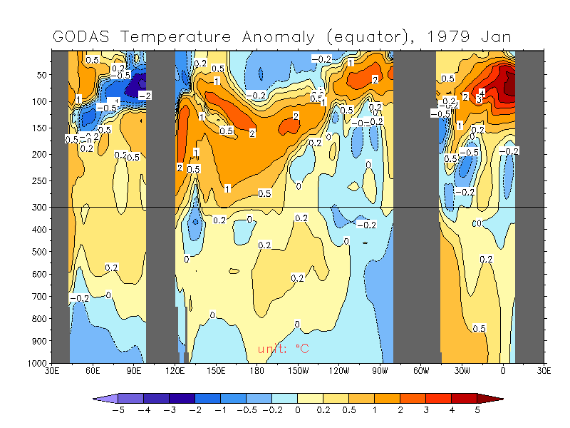
Global X-Z Temperature Anomaly Animation at the Equator
The second is the animation of subsurface temperatures at the equator to depths of 1000 meters (Global X-Z animation at 0N).
YouTube Link:
http://www.youtube.com/watch?v=Xc39fnIWYFw
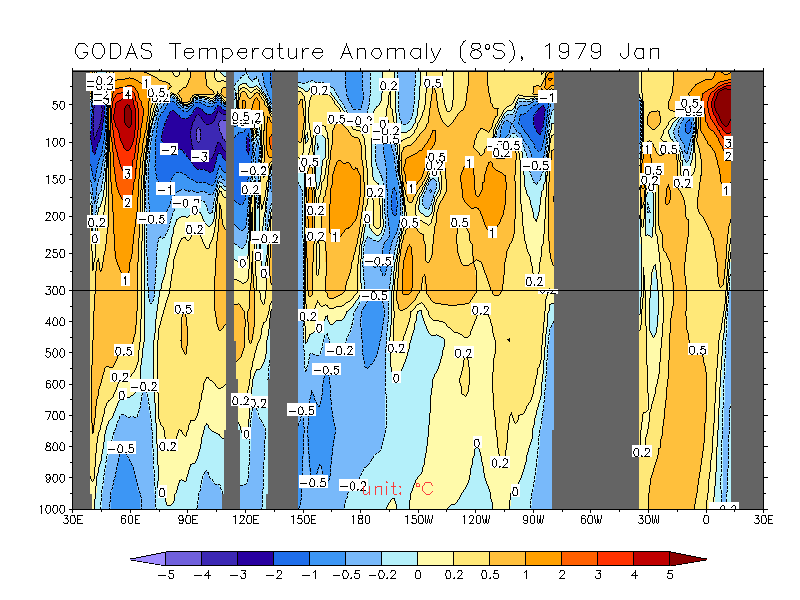
Global X-Z Temperature Anomaly Animation at 8S Latitude
The last is the animation of subsurface temperatures at 8S to depths of 1000 meters (Global X-Z animation at 8S).
YouTube Link:
http://www.youtube.com/watch?v=xuppLq3xotA
SOURCES
The direct link for download (Right click and “Save Target As…”) is here for the GODAS .gif of the Pacific Zonal Average Temperature animation:
movie.v.pacific.mon.gif
The link for the Global X-Z animation at the equator is:
movie.temp.0n.mon.gif
And the link for the Global X-Z animation at 8S latitude is:
movie.temp.8s.mon.gif
I’ve moved to WordPress: http://bobtisdale.wordpress.com/
Subscribe to:
Post Comments (Atom)
Donations
Tips are now being accepted.
Blog Archive
-
▼
2010
(95)
-
▼
March
(11)
- GISS Acknowledges Addition of ERSST.v3b Data To Th...
- Which Has The Greater Impact On Global SST Anomali...
- PRELIMINARY March 2010 SST Anomaly Update
- The Inverted ENSO Signal In The SST Residuals Of T...
- Absolute Land Surface Temperature Dataset
- Mid-March 2010 SST Anomaly Update
- Is There A 60-Year Pacific Decadal Oscillation Cycle?
- Absolute RSS MSU TLT Data
- February 2010 SST Anomaly Update
- PRELIMINARY February 2010 SST Anomaly Update
- GODAS Subsurface Temperature Anomaly Animations – ...
-
▼
March
(11)
Comment Policy, SST Posts, and Notes
Comments that are political in nature or that have nothing to do with the post will be deleted.
####
The Smith and Reynolds SST Posts DOES NOT LIST ALL SST POSTS. I stopped using ERSST.v2 data for SST when NOAA deleted it from NOMADS early in 2009.
Please use the search feature in the upper left-hand corner of the page for posts on specific subjects.
####
NOTE: I’ve discovered that some of the links to older posts provide blank pages. While it’s possible to access that post by scrolling through the history, that’s time consuming. There’s a quick fix for the problem, so if you run into an absent post, please advise me. Thanks.
####
If you use the graphs, please cite or link to the address of the blog post or this website.
####
The Smith and Reynolds SST Posts DOES NOT LIST ALL SST POSTS. I stopped using ERSST.v2 data for SST when NOAA deleted it from NOMADS early in 2009.
Please use the search feature in the upper left-hand corner of the page for posts on specific subjects.
####
NOTE: I’ve discovered that some of the links to older posts provide blank pages. While it’s possible to access that post by scrolling through the history, that’s time consuming. There’s a quick fix for the problem, so if you run into an absent post, please advise me. Thanks.
####
If you use the graphs, please cite or link to the address of the blog post or this website.
2 comments:
Bob, all you need to do is add some 60's psychedelic rock and you will have reproduced the actual lava lamp effect. All kidding aside, the animations show a highly dynamic thermal environment. What are the mechanisms that create the vertical transport of warm and cold water?
Howard: There are many subsurface currents in the tropical Pacific that strengthen and weaken seasonally and during ENSO events as the warm water sloshes back and forth. The following is a map view of the currents:
http://www.pmel.noaa.gov/pubs/outstand/kess2580/images/fig05.gif
It’s Figure 5 from a multipart post of a paper by Bill Kessler of NOAA “The circulation of the eastern tropical Pacific: A review”. Link:
http://www.pmel.noaa.gov/pubs/outstand/kess2580/introduction.shtml
In addition, most discussions of Meridional Overturning Circulation pertain to multidecadal circulation where the waters are subducted at high latitudes and drop to deep ocean layers, but MOC is also taking place in much shorter time periods nearer the surface. For starters, refer to:
http://www.aviso.oceanobs.com/fileadmin/documents/OSTST/2002_b/lee.pdf
Also, since the animations are looking at anomalies in cross sections, warm and cool subsurface “pools” of water can be moving horizontally and give the illusion that there’s vertical movement as they move into and out of the field of view.
Post a Comment